Sunday, August 28, 2005
Big Brother's Watching
This post has been reposted, with images edited in a coward attempt to safeguard my own ass, as I do not wish to land my butts behind bars.Ok.. In 'Enemy of the State' fashion... I'm feeling jittery all over. One reason is becos I am already running late meeting my bunkmates, another reason is the revelation that I am about to give. Although I AM late.. but this is something which I simply CANNOT hold back even 1 second longer. This discovery is just simply overwhelming!! I simply MUST blog it NOW.
The images below can be extremely disturbing to some. View with caution.
Take a deep breathe in...
.
.
.
.
.
.
.
.
And out.
.
.
.
.
In...
.
.
.
.
.
.
And out.
.
.
.
.
.
.
.
Ready?
.
.
.
.
.
.
.
NOW!
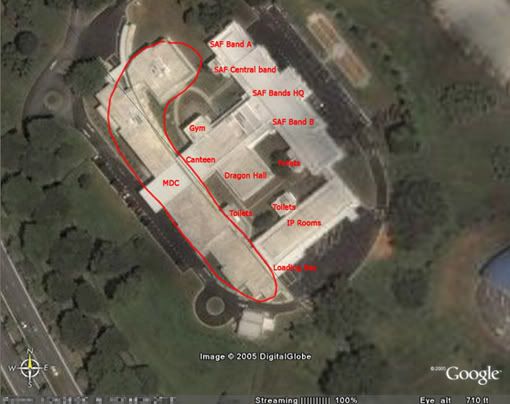
The 'White House', home of SAF Bands
Take a deep breathe in...
.
.
.
.
.
.
.
.
And out.
.
.
.
.
In...
.
.
.
.
.
.
And out.
.
.
.
.
.
.
.
Ready?
.
.
.
.
.
.
.
NOW!
The 'White House', home of SAF Bands
I came across this software called Google Earth from Weng's blog... in which he said Chris was the one who stumbled upon it. Apart from the cool factor of this Google Earth thingey, I was literally blown over by the immense power of this supposedly geeky online toy. I mean.. look, this is no ordinary map that I have posted above. It is the White House.. home to SAF Bands. It's a military building belonging to the SAF... situated deep within the huge Nee Soon Camp, which happens to be an ARMY camp, for goodness sake. And what is this?? I can simply zoom in and see EVERY GOD DAMN THING IN IT?!?! I mean.. seriously.. doesn't this pose some serious security issues??? Look, I can even NAME EVERY GOD DAMN ROOM!! If this is not a breach of security, I don't know what is.
True enough, you may argue that Nee Soon camp is not that important afterall, but I used this becos I work in that place everyday and I know it inside out. If anyone of you is from some camps of higher security level, do try and see if you can spot EVERYTHING in your camp. I seriously think you will. I have personally seen satellite images of the Istana, the MINDEF headquarters, the naval bases and all the airbases... And if the image above is not enough to convince you, here's more.
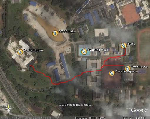
Route taken by foot in camp
True enough, you may argue that Nee Soon camp is not that important afterall, but I used this becos I work in that place everyday and I know it inside out. If anyone of you is from some camps of higher security level, do try and see if you can spot EVERYTHING in your camp. I seriously think you will. I have personally seen satellite images of the Istana, the MINDEF headquarters, the naval bases and all the airbases... And if the image above is not enough to convince you, here's more.
Route taken by foot in camp
The path in red is the route one will usually take to and fro White House, the bunk and the Cookhouse. Does this convince you now? (Who says bandsmen are pampered lucky people? See how far we have to go just to get some food in out mouth for every meal??? And if we need to change attire... $#%&@!)
Initially, I have posted the original images from Google Earth, totally unedited except for the labeling... And when my army mates heard of it... they gave me the are-you-sure-it-is-ok kind of look... which kinda made me think twice of wat I did. Ok, I'm sure I'm no Xiaxue or watever.. and my blog readership definitely isn't that awesome. But they do have a point that this is still an army camp afterall... and my revealing of what's inside, together with the coordinates, isn't that good a thing to do. Well, I dun want to take the risk too, though I do not know of any military law that prohibits one from exhibiting what he knows online, with regards to camp issues that do not have the word 'classified' or 'confidential' sprawled across it. In this case, the knowledge of bearings and directions... and also, I wun want to walk up to White House one fine day to see SIB, MP or RPs there waiting for me, handcuffs in hands.
Thus, after much contemplation, I decided to censor the coordinates.
And as we discuss this discovery in bunk.. and I argued dat it's seriously something the SAF, or any military organisation can't run away from. That is, satellite images of their camps from being shown. I mean, you can't stop technology from advancing. You cannot stop people from using binoculars, CCTV or wat have you, even if it invades YOUR privacy.. and you can't stop people from expression their views... cos dat is the 'freedom of speech'( so hot a topic when they came up with the 'Speaker's Corner', some pooty white elephant that it is now). And you can't stop people from bringing in devices which supposedly pose a threat to security, like cameras, phones and camera phones. Haha~
Which brings me to another thing. What the hell do SAF pose restrictions to prohibit camera phones in camps?? Almost every god-damn phone now is boasting of camera functions. Surely you cannot stop everyone from bringing one to camp, using 'security concerns' as a justification. You simply CANNOT stop technology from advancing! If anyone were to have ideas of taking photos of sensitive stuff in camp, I am very sure they will have ways to do that, with something even more advanced den a camera phone. Like a 500 times tele-photo zoom camera with 1000 mega pixels... k k.. too exaggerating. The point is, if anyone were to have ill-intentions of bringing the camp down or leaking sensitive documents, a camera phone will definitely not be the tool of choice. And they will have access to tools that are way more advanced den a lousy VGA or 1+ megapixels phone. Surely the authority should spend more time educating army personnel on the responsible use of camera phones and the moral and ethical issues when handling sensitive military information, and not simply restricting the use of certain geeky gadgets (which people will still find loopholes and smuggle them into camps anyway).
And there's the Catch-22 behind the Google Earth images. Government bodies all over the world simply have no rights over the images owned by Google Earth. And requests to obscure certain areas within their countries will be as good as announcing to the whole world (and to all the terrorists) where to aim their next missile.
As such, one can only wait with fingers crossed that Google Earth will not be the next geeky choice of tool for the terrorists out there.
Cre8tivesparks at 8/28/2005 07:09:00 PM
0 comments
Quotable Quotes
He who rambled


Wishlist
- Computer table
- KVM switch
- Digital SLR camera
- Printer
- Firewire card w/ firewire
- Small TV (for video editing purposes)
- Graphire Wacom Tablet
- Mini Hi-fi
- Laptop
- Singlet
- Jeans
- Belt w/ big buckle
- Strap for Fossil watch
- Sling bag
Upgrade comOptical mousePortable harddisk1gb ThumbdriveCurtainsBig THANKS to Yiqiang for helping me with the installation!Underbed containersEarphonesThanks Yiqiang!MP3 PlayerThanks Yiqiang!
Flickr badge
- Removed
Get Firefox
Previously
- Latest Entry
- November 2004
- December 2004
- January 2005
- February 2005
- March 2005
- April 2005
- May 2005
- June 2005
- July 2005
- August 2005
- September 2005
- October 2005
- November 2005
- December 2005
- January 2006
- April 2006
- May 2006
- June 2006
- July 2006
- August 2006
- December 2006
- January 2007
- November 2007
Read on
- Alvin's
- Snailz's
- Yanxin's
- Yiqiang's
- Benji's
- Chenguo's
- Dennis'
- Gerald's
- Jincheng's
- Negoki's
- Weng's
- Weiye's
- Zat's
- Earthroamer's
- Kai's
- Eugene's
- Geraldine's
- Gloria's
- Hans'
- Jas'
- Liangcheng's
- Nel's
- Nico & Anon's
- Qingyu's
- Schmetterling's
- Wenjie's
- Woon Keat's
- Yuffer's
- Zhanz's
Tagboard

Counter
visitors since God-knows-when
Blogroll
Game
Credits
Links
- Removed